[et_pb_section bb_built=»1″ fullwidth=»on» _builder_version=»3.17.2″ background_color=»rgba(12,113,195,0.08)» background_blend=»overlay» saved_tabs=»all» box_shadow_vertical__hover_enabled=»on» box_shadow_vertical__hover=»12px» next_background_color=»#ffffff»][et_pb_fullwidth_post_title meta=»off» featured_image=»off» text_color=»light» _builder_version=»3.17.2″ title_font=»Handlee|700|||||||» title_text_align=»center» title_text_color=»#1859b8″ title_font_size=»35px» custom_padding=»50px||0px» /][/et_pb_section][et_pb_section bb_built=»1″ admin_label=»section» _builder_version=»3.17.2″ transparent_background=»off» box_shadow_style=»preset3″ prev_background_color=»rgba(12,113,195,0.08)» next_background_color=»rgba(12,113,195,0.08)»][et_pb_row custom_padding=»0px||0px|» background_color_2=»rgba(255,255,255,0.82)» parallax_method_1=»off» parallax_method_2=»off» _builder_version=»3.17.2″ background_size=»initial» background_position=»top_left» background_repeat=»repeat»][et_pb_column type=»4_4″][et_pb_text admin_label=»TextTurismoActivo» _builder_version=»3.21.1″ text_font_size=»17px» header_font_size=»22px» custom_margin=»-40px|||» custom_padding=»50px|10px|50px|10px» use_border_color=»off» border_color=»#ffffff» border_style=»solid» z_index_tablet=»500″]
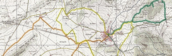
Route of «Las Ramblas»
Starting Point: Juan Carlos I Square. Arrival Point: Plaza de Juan Carlos I. Approximate Elevation: From 520 m. At 578 m. Estimated Time: 1 h. 15 min. Length: 12,250 m. Estimated Average Speed: 18 km / h. Difficulty: Medium Terrain: Roads roads, sections of ramblas and asphalted roads.
Map of the route
Itinerary
[/et_pb_text][/et_pb_column][/et_pb_row][/et_pb_section][et_pb_section bb_built=»1″ _builder_version=»3.17.2″ background_color=»rgba(12,113,195,0.08)» custom_padding=»0px||0px|» transparent_background=»on» prev_background_color=»#ffffff» next_background_color=»#ffffff»][et_pb_row admin_label=»row» _builder_version=»3.0.47″ background_size=»initial» background_position=»top_left» background_repeat=»repeat»][et_pb_column type=»4_4″][et_pb_image admin_label=»ImgTurismoActivo» show_in_lightbox=»on» use_overlay=»on» align=»center» _builder_version=»3.21.1″ max_width=»300px» use_border_color=»off» border_color=»#ffffff» border_style=»solid» animation=»off» sticky=»off» src=»https://www.alguenya.es/wp-content/uploads/2025/01/portada_ruta_lasramblas.jpg» z_index_tablet=»500″ /][/et_pb_column][/et_pb_row][/et_pb_section][et_pb_section bb_built=»1″ _builder_version=»3.7″ custom_padding=»0|0px|54px|0px|false|false» saved_tabs=»all» prev_background_color=»rgba(12,113,195,0.08)»][et_pb_row _builder_version=»3.0.47″ background_size=»initial» background_position=»top_left» background_repeat=»repeat»][et_pb_column type=»4_4″][et_pb_post_nav in_same_term=»on» _builder_version=»3.8″ title_font=»|600|||||||» title_text_color=»#363c91″ use_border_color=»off» border_color=»#ffffff» border_style=»solid» hide_prev=»off» hide_next=»off» /][/et_pb_column][/et_pb_row][/et_pb_section]